Saturday, September 8, 2012

September 6, Donner Pass

At Sid's Restaurant in Auburn, NV I had the best cornbread ever!!! It had pineapple in it. It took away any bitter taste but without a sweet taste. Yum!

This was a day packed with interesting observations. We started in Auburn, NV where we spent the night. We stopped by the Chamber of Commerce where we saw the statue commemorating the Chinese workers that helped build the Central Pacific Railroad. The Central Pacific started from Sacramento, CA and the Union Pacific started from Omaha, NB with the two meeting at Promontory Point, Utah for completion of the first transcontinental railroad.


This statue is "The Chinese Coolie" made by an Auburn dentist in 1972. The term "coolie" was Hindu meaning unskilled labor and at the time was not a derogatory term. He used a mile of rebar in making it.
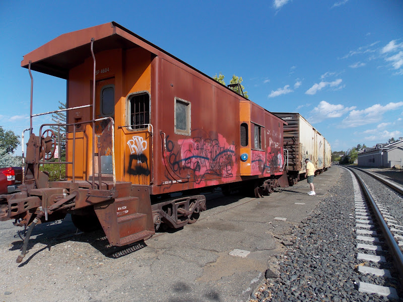


This caboose is sitting on the original line of the Central Pacific in Auburn, CA. This is behind the Chamber of Commerce.


This is the West end of Bloomer's Cut in Auburn. It is the same as it was when it was built in 1865 and it is still used by the railroad.It is 800' long and 63' tall.


This is the Bloomer's Cut from the East. There was nothing in town to tell us how to get here so we went online and found directions. We had to drive through residential areas, go to a dead end street then hike about 300' to get there. There was only a dirt path leading there but you could tell several weirdos like us go there to see it.


At a rest stop in the Sierra Nevada Mountains. One route that the California emigrants used was through here. We wondered how they could have ever gone through.


More rocks.


This is a picture of a painting of the wagons trying to get up and down the rocks of the Sierra Nevada. Later we were at an interpretive center and saw these paintings.
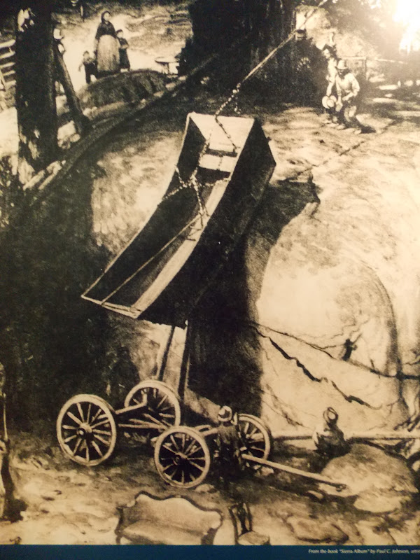


We had read about this and this painting shows how they tore their wagons apart and pulled them piece by piece over the rocks then put them back together. Their belongings were many times carried by hand.


Donner Summit. The above paintings were of this area. Here is where the Reed & Donner party got stranded during the winter with heavy snows and no food.


  In the middle left of the picture you can see a covered railroad track and where it disappears into a tunnel. This is also at Donner summit. The Central Pacific Railroad had crews working, in shifts, 24 hours a day and were still only able to cut 6" to 12" a day through these mountains.


The stone wall under the tracks they called the Chinese Wall because almost all of the workers were Chinese. They worked harder than the American workers and were healthier. They drank their tea which was made with boiled water while the Americans drank from streams or ponds and often were sick with diarrhea or other diseases.


Here you can see the covering over the tracks to prevent snow from stopping train traffic. This was an American invention which was later used in the Swiss Alps and other places.You can see where the tracks enter a tunnel. There were 6 tunnels drilled in the Sierra Nevada Mountains.


You can see a short tunnel in the center of the picture and a longer tunnel on the left. This part of the train route is no longer used.


Neither of us had ever seen rock climbing like this. We decided that we are not going to take up this sport.


This bridge is almost to the top on the way up to Donner pass and where all the train track pictures were taken. It is old US 40 and still in use. We drove over it.


This is a picture of the bridge rails on a bridge on the first transcontinental highway. They were built in 1914. The highway was called the Lincoln Highway and went between New York City and San Francisco. It was build between 1913 and 1917. When numbering of roads was begun this highway was renamed US 40. In the 1970s it was replaced by Interstate 80.


They restored the old bridge rails and they are currently at a rest stop on I-80 near where they were originally.


Almost as soon as we left Donner Pass and were on the east side of the Sierra Nevada Mountains, the scenery changed to desert mountains with no trees and no vegetation except for an occasional sage brush. There were no rocks of any kind.


Wednesday, September 5, 2012

September 5, Auburn, CA

Today we mostly drove. We stayed last night in Redding then this morning drove up to Mount Shasta, which at 14,179'. We drove through very thick smoke where we couldn't see 1/4 mile ahead. It cleared by time we got farther north and we could see the mountain well.

We were back into the high 90s or even 100 today. It was really chilly yesterday in Eureka where the high was only in the low 60s.

We also saw signs along the interstate that said to watch for bears crossing the road.


This was taken about 30 or 40 miles away and you can see some of the smoke. We were very glad that it cleared.


This was taken from the soccer pitch in the city of Mount Shasta.


This shows more of the mountain. This isn't the view that most pictures show but we didn't have an entire day to drive around and up it. You can drive as high as 8,000 feet.


Just a little different perspective.


We were going to go to a bookstore in Redding that has 300,000 books, records and comics but it was closed today. I thought Ed was going to cry. Ha. It has rave reviews online.

We then drove on south on a state highway through Chino. For many miles north and south of Chino there are fruit fields as far as you can see. We stopped at a stand to get some fresh fruit to eat and the woman there said that they grow peaches, apricots, plums, walnuts, olives, pistachio, and probably more. I tried a pluot which is a cross between a plum and an apricot. It was delicious!

September 4, Eureka, CA

We spent a lot time in used books stores and quilt shops. For a change, Ed bought more books than I bought pieces of fabric. I think I will have purchased a piece of 30s/40s replica fabric from every state that we have been in since I began my Cathedral Windows quilt and will be able to incorporate them.

While we were walking around town we saw a skinny man without a shirt (temperature was about 61 degrees) breaking the lock so he could get into a trash can. He kept rubbing his nose which was running (not a cold), picking at his arms and clothes, and twitching around. I went into an attorney's office to let them know and the secretary thanked my and said they have a policeman who comes to get people like that. Evidently, just a routine occurrence. It was sad to see someone so addicted to drugs. There were a tremendous number of homeless people all over the streets and some who were just a little strange looking.

Eureka has many, many old Victorian houses. Here are just a couple.

This is the most beautiful Victorian house we have ever seen. It was built by William Carson, a pioneer lumberman.The tower has windows on all four sides and the small rectangular windows are stained glass. The section to the left has a balcony on it rather like a Swiss chalet.


Around and under the windows is some kind of like a widow's walk.


Just another beautiful and beautifully restored house.


Last but not least, only in California!!!!!! It was a gravel parking lot.


We both decided that we are not ready to pack up and move to Eureka.

Tuesday, September 4, 2012

September 3, Redwood Forests

The Redwood Forests are stunning. The trees are soooooo very tall and straight and there are so many trees growing together in one area. The Redwood is the world's tallest living tree and grow from seeds the size of a tomato seed.


This is a typical tree. The branches are towards the top of the tree so you don't really see them on the mature trees.


This shows how small the needles are and you can see a pine cone to the right of the forefinger. It is bout the size of a large olive.


This tree has a huge burl on the bottom. This is where another tree can start. Many times a tree will start from it and you may have 2 to 5 trees all growing together and connected at the base.


This shows how a new tree has started growing from the top of a dead tree.


We've seen pictures of this but it is really strange to see it for real. We were along the coast and the fog had rolled in but was only a few hundred feet high and we were above it so it was like flying in an airplane and seeing the clouds below you. Rather a surreal sight.


Here you can see where a new tree started growing on top of a log of a dead tree. These are along the coast so they get a lot of rain but also when the fog is covering the area the tree absorb moisture from the fog.


This is simply called Big Tree. It is 21.6' in diameter, 66' in circumference, 304' tall and 1,500 years old.


The Redwoods are astounding but seeing the elk was EXCITING!!! This was the leader of the group. You could tell he was by the way he stayed around the others and by the rack on his head. Wow! There were 2 other males with smaller antlers who stayed in another part of the meadow and a couple of very young ones with just the dark neck and head.


Here are more of the herd.


September 2, Crater Lake

Today we drove up to Crater Lake where we spent 6 hours, plus 3 hours driving to and from, plus hiking/walking. We were tired puppies! We were also the minorities 90% of the time. We saw people from and heard the languages of Japan, India, Pakistan, Germany, Mexico and probably others. What hit me on the drive home was that we did not see one African American.

Crater Lake is worth the out-of-the-way drive to get to. How and when it was formed, the forces of nature even today and the pristine beauty of phenomenal! The roads around most of the lake close in October or November because of snow and the entire loop doesn't open until June or July. They get 44 feet of snow each year (528"). The winds blow terribly all winter at the top and the trees are terribly malformed.


This is just how wooded our about 40 mile drive up to the lake was.


This is Wizard Island which is volcanic rock and is one of only 2. There is no spring to feed the lake. It is filled only by rainfall and melting snow. The amount that enters it each year equals the amount evaporated each year.


All around the lake the reflection off things is wonderful because there are no boats or ducks or geese or anything on it. There are some fish in it.


Mount McGlothin on the left.


Surprised that I don't have my Blackhawks shirt on? I really do have other clothes. :)

There are several places where there are still snow drifts.


This is called Phantom Ship. It is just a little island.


Just a pretty picture.


Another view of Wizard Island. Look at the still lake water.


These are the Pinnacles which are "fossil fumaroles" where volcanic gases rose up through a layer of volcanic ash, cementing the ash into solid rock.


These are Vidae Falls which originates from a spring fed creek and goes down 100 feet over a series of ledges.


There were not that many people in the park so there were times that we were the only ones in an area and it was incredibly quiet. Even the birds didn't chirp all the time. It was really peaceful.

Saturday, September 1, 2012

September 1, Medford, OR

We had to buy gas today and were lucky to get it for $3.96. We saw it as high as $4.23 for regular unleaded gas.

The first time we bought gas in Oregon a man came dashing toward the car and said he would pump it. We discovered later that there is a law in Oregon that there can be NO self-serve gas stations. The stations have to hire people who are on welfare to pump the gas. This way people on welfare have to work for their money. We have been discussing the merits of this for several days.

We didn't drive far today since this was our laundry day. That is done and we hope to have an early start tomorrow to drive up to Crater Lake for the day. This is as close to Crater Lake as we could find lodging on the holiday weekend.


We went to the Logging Museum in Coos County, Oregon and saw this. If any of you have watched many old B western movies, you should recognize this as a dynamite blasting machine. Attach the wire on one end to the dynamite and the other end to this. Then pull up the handle and push down quickly and run away before it explodes and buries the good guys!


This tree is the Oregon myrtle tree and is very old and large. All along the roads we have seen signs that say they sell myrtle objects. The wood is very beautiful and harder than black walnut we were told. It is not used in building though because it contracts and expands depending upon the humidity. We saw gorgeous carvings using this wood.


These are the leaves of the Oregon myrtle tree which we were told could be used in cooking in place of bay leaves. They are shaped very similar to the bay leaf. I didn't think to pull one off and smell or taste it. I will if I get close to another tree.


August 31, Coos Bay, OR

We started down the Oregon coast on highway 101. At the start we were right on the ocean then we went in a little. Most of the way was all "resort" build up and like the west coast of Florida except not as many people. 

Tillamook County has 2 quilt trails. One is around the countryside and small towns and the other one is in the city of Tillamook. We saw a few of the blocks are we drove. I also got a list of the Oregon coast quilt shops. There are 13. I'll not be able to make all of them!!!

Another interesting thing is all the signs telling you that you are either entering or leaving tsunami hazard areas. They have signs telling you the evacuation routes.

The number of bicycles along 101 is amazing. Almost all of them have paniers filled so you know they are biking for several days. They road is very hilly with a few small mountains thrown in. They have a berm on both sides of the highway for the bikers to use. Going through tunnels or over bridges they use the vehicular road and cars and trucks give them space to ride. The road is called the Oregon Coastal Bikeway. Just before you enter a tunnel there is a sign telling you that if the light is blinking, there is a bicyclist in the tunnel so you know to watch out for him or her.

The highest price gas that we saw today was $4.14 and the lowest was $4.09.

I laid out 2 pair of jeans to bring with me and somehow they didn't get packed so thank goodness there was an outlet mall in Seaside where we stayed last night so I went to Eddie Bauer and got a couple of new jeans.

We ate lunch at a quintessential greasy spoon restaurant today. It was sooo greasy that I couldn't eat all the food. Ed thought it was great!


This was our first real look at the Pacific Ocean. It was very windy and hazy. We assume the haze is from the sand and salt that is blown up from the beach and ocean. Even though it was only 63 degrees, there were some kids along the way who had on bathing suits and were playing in the water. Adults had on long pants or shorts with sweatshirts.


There are places along the coast where it is all sandy beaches, other places where it is all straight walled cliffs and others where it is a combination.


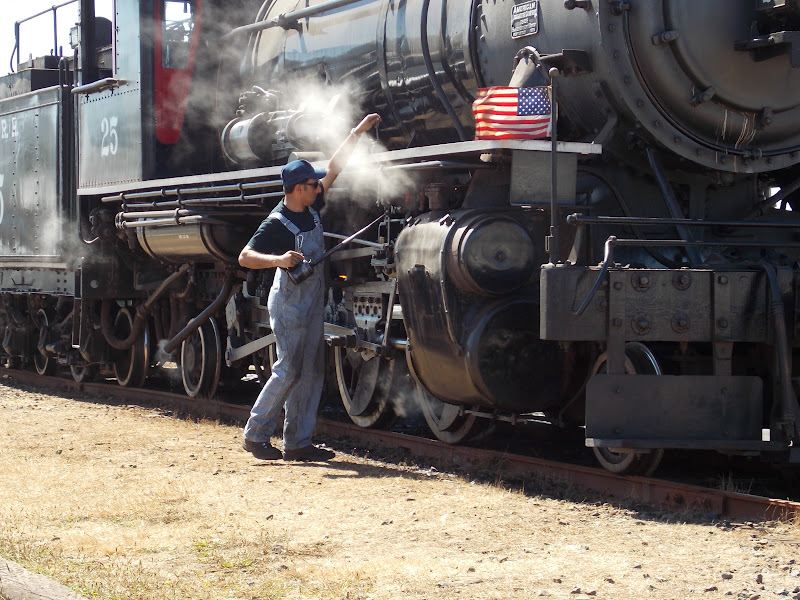
At one place you can take a ride on a steam locomotive pulled train. Here the engineer is oiling the engine. Kids, we will show you an oil can when we get home. You used to have to put oil in parts of the car, sewing machines, lawn mowers, and almost any other piece of equipment that had moving parts.
I didn't think until now that the kids have probably never seen anything being oiled!


Here is the entire engine with the coal car where they shovel the coal into the burner which boils water and makes steam which runs the engine. The train has a really different sounding horn than the ones that go by our house.


Here is another unique looking bridge that we crossed. This one is just north of Coos Bay where we are staying.


There are several miles of sand dunes just north of Coos Bay. Here you can see the dune buggies and ATVs that you can drive onto the dunes. The dunes go inland for at least about 1/4 mile.